/* analytic ----------------------------------------------- */

Tuesday, March 31, 2009

Tanjung Puting National Park

anjung Puting National Park has several ecosystem types: lowland tropical rain forest, dryland forest, freshwater swamp forest, mangrove forest, coastal forest, and secondary forest.

The Park is dominated by lowland forest plants like jelutung (Dyera costulata), ramin (Gonystylus bancanus), meranti (Shorea sp.), keruing (Dipterocarpus sp.), and rattans.

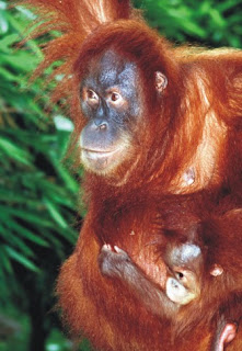
Endangered and protected species of animal inhabiting the Park include the orangutan (Pongo satyrus), proboscis monkey (Nasalis larvatus), maroon leaf monkey (Presbytis rubicunda rubida), sun bear (Helarctos malayanus euryspilus), lesser Malay mouse deer (Tragulus javanicus klossii), clouded leopard (Neofelis nebulosa), and leopard cat (Prionailurus bengalensis borneoensis).

bali villa hotel
bali villa hotel


This Park was the first place in Indonesia to become a rehabilitation centre for orangutans. There are now three orangutan rehabilitation locations, Tanjung Harapan, Pondok Tanggui, and Camp Leakey.

The orangutan of Kalimantan has dark reddish fur and no tail. As they get older, the adult males cheeks flesh out, resembling cushions. The older they get, the bigger these cheek flanges grow, giving them a fierce look.

UNESCO has declared Tanjung Puting National Park as a Biosphere Reserve, and it is also a Sister Park to Taman Negara Malaysia under a cooperation agreement between Indonesia and Malaysia

Interesting locations/attractions:

Tanjung Harapan: this is the first station in the orangutan rehabilitation process. Situated in the midst of secondary forest and swamp forest, it has a guesthouse, an information centre, and trails.

Pondok Tanggui: orangutans that have passed the semi-wild phase are moved to Pondok Tanggui. There, they are closely monitored from a distance, and human contact is avoided.

Camp Leakey: founded in 1971 in the middle of primary forest, this is the location for semi-wild and wild orangutans, and for younger orangutans from birth until three years of age.

Natai Lengkuas: bekantan research station, and watching other animals along the river. Buluh River and Danau Burung ("Bird Lake"): watching birds, in particular migrant species.

Among the cultural attractions outside the Park is a traditional rowing contest held in Pangkalan Bun in May.

Best time of year to visit: June to September.

How to reach the Park: Jakarta-Semarang-Pangkalan Bun by plane, or from Semarang to Pangkalan Bun by ship. Pangkalan Bun-Kumai by car (8 km). Then, Kumai-Tanjung Harapan by motorized longboat, 1.5-2 hours; or Kumai-Natai Lengkuas, 4-5 hours; Kumai-Tanjung Harapan by fast motor boat, 0.5-1 hour; Kumai-Camp Leakey, 1.5-2 hours; or from Kumai-Natai Lengkuas, 1.5-2 hours.

Office: Jl. HM Rafii Km 2 Pangkalan Bun, Kotawaringan Central Kalimantan Tel./Fax. : +62-532-23832

Declared Minister of Agriculture, in 1982,
a total area of 300,000 hectares
Designated Minister of Forestry SK No. 587/Kpts-II/96,
a total area of 415,040 hectares
Location Regency of Kotawaringin (Province of Central Kalimantan)

Temperature 22° - 33° C
Rainfall 2,400 mm/annual (on average)
Altitude 0 - 100 m asl.
Geographical location 111°42' - 112°14' E; 2°33' - 3°32' S

Source : http://www.dephut.go.id
Read More......

Gunung Rinjani National Park

Gunung Rinjani National Park represents a range of Nusa Tenggara's ecosystem types, from sub-montane rain forest to montane forest and savanna.

The plant potential in this Park area includes jelutung (Laportea stimulans), dedurenan (Aglaia argentea), bayur (Pterospermum javanicum), beringin (Ficus benjamina), jambu-jambuan (Syzygium sp.), keruing (Dipterocarpus hasseltii), rerau (D. imbricatus), lumut jenggot (Usnea sp.), cemara gunung (Casuarina tripolia and C. equisetifolia), edelweiss flowers (Anaphalis javanica), and endemic species of orchid such as Perisstylus rintjaniensis and P. lombokensis.


rinjani
rinjani
There is one endemic species of civet in the Park, namely the musang rinjani (Paradoxurus hemaproditus rinjanicus). Also to be found in the park are barking deer (Muntiacus muntjak nainggolani), ebony leaf monkey (Trachypithecus auratus kohlbruggei), pangolin (Manis javanica), southeast Asian porcupine (Hystrix brachyura), Timor helmeted friarbird (Philemon buceroides neglectus), crested hawk eagle (Spizaetus cirrhatus floris), lesser sulphur-crested cockatoo (Cacatua sulphurea occidentalis), Lombok honeyeater (Lichmera lombokia lombokia), dark-backed imperial pigeon (Ducula lacernulata sasakensis), black-naped oriole (Oriolus chinensis broderipii), and several species of reptile.

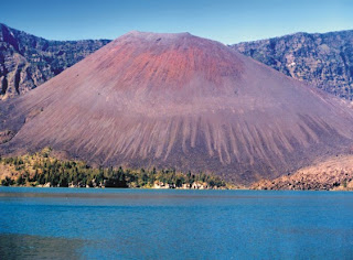
Mt. Rinjani, at 3,726 m asl., is the third highest mountain in Indonesia. In a valley high up on the western part of Mt. Rinjani lies Segara Anak Lake (2,208 m asl.) whose sulphurous-smelling water has different temperatures from one part of the Lake to another, ranging from cool, through warm, to very hot. A new volcano is emerging from the centre of this Lake, and it is still active and growing.

Particularly with the coming of the rice-planting season, the communities in the vicinity quite often hold ritual ceremonies on Mt. Rinjani and at Segara Anak Lake. One involves releasing small artificial fish made of very thin gold into the Lake.

Interesting locations/attractions:

Mt. Rinjani: mountain climbing and camping.

Segara Anak Lake, Sebau and Gunung Baru: research, enjoying natural phenomena, thermal springs, bathing, observing animals and exploring the forest, cultural attraction.

Otakokkoq and Kembang Kuning: enjoying thermal springs and waterfalls.

Cultural attractions outside the Park area include, in Mataram, Perang Topat in December, and Ciwaratri in January.

Best time of year to visit: August to December.

How to reach the Park: there a number of options. Mataram-Selong-Sambelia-Sembalun Lawang by car, 4.5 hours (140 km), then on foot to Segara Anak Lake, 9 hours (25 km). Or Mataram-Bayan-Senaru by car, 2.5 hours (82 km), then on foot to Segara Anak Lake, 9 hours (25 km). Alternatively, Mataram-Bayan-Torean, 2.5 hours (85 km), then on foot to Segara Anak Lake, 7.5 hours. Or Mataram-Masbagik-Kutaraja-Tetebatu, 1.5 hours (60 km), then on foot to Otakokkoq, 30 minutes.

Office: Jl. Erlangga 88, Mataram
West Nusa Tenggara
Tel. : +62-370-627764
E-mail: tngr@indo.net.id.

Designated : Minister of Forestry, SK.No.280/Kpts-II/97,
a total area of 41,330 hectares
Location : Regencies; West Lombok, Central Lombok and
East Lombok, Province of West Nusa Tenggara

Temperature 23° - 30° C
Rainfall 2,000 mm/year (on average)
Altitude 550 - 3,726 m asl.
Geographical location 116°18' - 116°32' E; 8°18' - 8°33' S

Source : http://www.dephut.go.id
Read More......

Monday, March 30, 2009

Bunaken National Park

Bunaken National Park is A flat island about 15 km from Manado, with a friendly people. The coral reefs off Bunaken island shouldn't be missed while you are in Manado. These magnificent virgin reefs are still relatively unspoiled. The drop-off walls at Liang cove is not only rare in the world, with caves, gullies and caverns, harboring an immense wealth of marine life. Spectacular formation of reefs begin with flat at about 5 m depth. These plunge downward to form underwater vertical crevices with often reach depth on several hundred meters. On these beautiful reefs, a wonderful collection of marine life thrives.

bunaken

bali villa hotel


The Bunaken reef is a chain of over 40 five star dive spots. The Marine Park is spectacular with the greatest concentration of tropical fish, coral species and world famous wall diving.
Clear, warm waters (sea temperatures usually range between 27-30 degrees C), light currents and calm seas allow easy access to the underwater attraction awaiting visitors to the five-islands of the Bunaken-Manado Tua National Marine Park which sits directly offshore of Manado. Bunaken is the standout favorite, with the highest density of schooling fish and the greatest probability to see larger species such as turtles, sharks, and napoleon wrasse. There are enough sites here to keep any diver happy for over a week without going elsewhere.


The Dive Sites :

Most diving takes place near Bunaken and Manado Tua, because of their many excellent sites. The following is representative of the diving in the area.

• Lekuan Walls (I, II, III)
This long wall on Bunaken is divided into three sites: Lekuan I, II and III. Together they represent the park's best. Steep walls are marked with deep crevices, sea fans and giant sponges. The shallows are filled with fishes. The wall, often protected from stronger currents, is frequented by bumphead parrotfish, turtles, and Napoleon wrasses.

• Mandolin
Mandolin has a knockout reef crest and a wall that attracts thousands of fishes like schooling fusiliers, surgeonfish, unicornfish, and bannerfish. They are acclimated to divers and are easily approachable.

• Bunaken Timor
There are strong currents and lots of fishes on this long wall. The shallow reef isn't as spectacular as some but there are turtles, sharks, eagle rays, and other big fishes in the blue. Overhangs and small caves mark the wall.

• Tanjung Kopi
Tanjung Kopi is a nice wall with a small school of barracuda and lots of sweetlips. Visibility in the shallows is not terrific but the numbers of fishes make up for it. Nudibranches and fire gobies are easy to spot here.

• Siladen Island
Siladen has a beautiful wall of soft corals that bloom when the current is running. The shallows are nice with lots of fishes and schooling snappers.

• Muka Gereja
Muka Gereja is a pretty site with thousands of fishes in the shallows and deeper canyons that lead to the wall.

• Barracuda Point
Barracuda Point, on northwest Montehage, is one of the furthest sites. A school of giant barracuda are regulars along with jacks and tuna.

• Manado Wreck
This 60m (200ft) long German merchant ship sank near Molas Beach in 1942. It sits upright with the bow at 23m (78ft). The ship is split near amidships back to the stern, exposing the wheelhouse and cargo holds. Dives finish up on a nearby shallow reef. Expect 10-15m (30-50ft) visibility.

Getting There

Bunaken Island is easily reached from Manado by motorized outrigger boat start from Manado harbor, Molas, Kalasey and Tasik Ria beaches. The public boats from Manado to Bunaken are leaving daily around 2 p.m (depending on tide), except Sundays, from Pasar Jengki near Manado harbor. Back from Bunaken to Manado usually early in the morning, around 7-8 a.m

Where to Stay

On the island you have the choice amongst a number of homestays, with rates starting at
Rp. 40 000 per day and person including full board. Some of the dive operations on Bunaken are offering more up-market accommodation, and even running water.

Moving Around

You can explore the land on foot. And you can use a boat to move from one dive sites to another sites.

Dining Guide

There are several of restaurants and cafes throughout Manado and the islands. Try their specialties: seafood, bubur manado and food made of coconuts!

Souvenir Tips

Sea-related products, such as items made of seashells, corals, etc

Other Things to See or Do

• Diving, swimming, and snorkeling.
• Walking around on the beach.
• Sampling the tempting seafood cuisine.
• Ornithologists and amateur bird-watchers might find visiting Tangkoko Dua Sudara Nature Reserve entertaining.

Travel Tips

• Entrance tags and tickets can be purchased through marine tourism operators based in Manado and in the Bunaken National Park, or can be purchased from one of three ticket counters in Bunaken and Liang villages on Bunaken Island and on Siladen Island;
• You should be aware that during the absolute peak season months July and August it usually gets VERY busy. Many of the better resorts and dive operators will not be able to accept walk-ins during that time since they are fully booked. Better make a reservation before;
• Try to hire equipment from larger firms as these tend to be more reliable, but remember the responsibility of checking the equipment is ultimately yours.


Read More......

Gunung Leuser National Park

Gunung Leuser National Park represents several ecosystem types, from coastal forest ecosystem through tropical lowland forest ecosystem to montane forest ecosystem. Most of the Park area is covered with thick Dipterocarpaceae forest with rivers and waterfalls flowing through it. There are some endangered and peculiar plants, namely daun payung raksasa (Johannesteijsmannia altifrons), rafflesia flowers (Rafflesia atjehensis and R. micropylora), and Rhizanthes zippelnii-the biggest flower, with a diameter of 1.5 metres. In addition, there is one plant unique to the area: the ara, a strangling plant.

bali villa hotel
bali villa hotel
Endangered and protected animal species which inhabit the Park include orangutan (Pongo abelii), siamang (Hylobates syndactylus syndactylus), Asian elephant (Elephas maximus sumatranus), Sumatran tiger (Panthera tigris sumatrae), Sumatran rhinoceros (Dicerorhinus sumatrensis sumatrensis), serow (Capricornis sumatraensis), great hornbill (Buceros bicornis), sambar deer (Cervus unicolor), and leopard cat (Prionailurus bengalensis sumatrana).

Gunung Leuser National Park has been declared a Biosphere Reserve. Under a cooperation program between Indonesia and Malaysia, the Park is also designated as a "Sister Park" to the Taman Negara in Malaysia.

Interesting locations/attractions:

Gurah: fantastic views, valleys, waterfalls; animals and plants such as Rafflesia, orangutans, birds, snakes and butterflies.

Bohorok: an orangutan rehabilitation centre; ecotourism activities like kayaking/canoeing, camping, and birdwatching.

Kluet: boating on rivers and lakes, trekking through coastal forest and caving. Kluet is also a habitat of tigers.

Sekundur: camping, caving, animal observation.

Ketambe and Suak Belimbing: suitable place for research on primates and other animals; research facilities include accommodation and a library.

Gunung (Mount) Leuser (3,404 m asl.) and Mt. Kemiri (3,314 m asl.): mountain climbing and hiking.

River rafting along the Alas River: start from Gurah-Muara Situlen-Gelombang for a three-day trip.

Cultural attractions outside the Park include the Lake Toba Festival in June (held on the Lake) and the Malay Culture Festival held in July in Medan.

Best time of year to visit: June to October.

How to reach the Park: Medan-Kutacane about 8 hours by car (240 km), Kutacane-Gurah/Ketambe about 30 minutes by car (35 km), Medan-Bohorok/Bukit Lawang about 1 hour by car (60 km), Medan-Sei Betung/Sekundur about 2 hours by car (150 km), Medan-Tapaktuan about 10 hours by car (260 km).

Office:
Jl. Raya Blangkejeren Nr. 37 Km 3 PO Box 16, Kutacane, Nanggroe Aceh D.
Tel. : +62-629- 21358
Fax. : +62-629- 21016
E-mail: tnglaceh@indosat.net.id

Declared : Minister of Agriculture, in 1980,
a total area of 792,675 hectares
Designated : Minister of Forestry, SK. No.276/Kpts-VI/1997,
a total area of 1,094,692 hectares
Location : Regencies Southeast Aceh, South Aceh,
Aceh Singkil (Province of Nanggroe Aceh Darusslam), and
Regency of Langkat (Province of North Sumatra)

Temperature 21° - 28° C
Rainfall 2,000 - 3,200 mm/year
Altitude 0 - 3,381 m asl.
Geographical location 96°35' - 98°30' E; 2°50' - 4°10' S

Source : http://www.dephut.go.id
Read More......

Kepulauan Seribu National Park

Kepulauan Seribu is one of Indonesia's marine nature conservation areas and it is located 45 km north of Jakarta.

The 78 coral islands, both large and small, with an average altitude of not more than 3 m asl, form a chain. Hundreds of years ago, the islands were formed upon colonies of dead coral. These colonies initially grew on shallow sea beds; their upper layers breached the surface and were weathered. Later, pioneer plants such as bushes and several tree species began to grow on the coral. The surface of the islands is quite different from soil-covered ground, and this is reflected in their diverse plant and animal life.

bali villa hotel
bali villa hotel
In general, the plants that grow in the Park are dominated by coastal species like coconut palm (Cocos nucifera), pandan (Pandanus sp.), cemara laut (Casuarina equisetifolia), cangkudu (Morinda citrifolia), butun (Barringtonia asiatica), mangrove (Bruguiera sp.), sukun (Artocarpus altilis), ketapang (Terminalia cattapa), and kecundang (Cerbena adollam).

ea vegetation commonly found in the Park consists of seaweed divisions like Rhodophyta, Chlorophyta and Phaeophyta as well as classes of sea grasses like Halimeda sp., Padina sp., Thalasia sp., Sargasum sp., and Caulerpa sp.

The dominant animals in the Park include 54 sea biota species which form part of the coral reef ecosystem, 144 species of fish, 2 species of giant clam, 6 species of sea grass, sea worms of various colours and 17 species of coastal bird.


This Park forms a hatching site for hawksbill turtle (Eretmochelys imbricata), and green turtle (Chelonia mydas). The hawksbill turtle is an endangered species and is rarely found in other waters. These turtles are bred on Pramuka Island. This activity is aimed at recovering the turtle population, which had almost reached extinction. Breeding activities include egg hatching in a semi-natural way and caring for the baby turtles till they are ready to be released into their natural habitat.

Most coastal areas of this Park are surrounded by mangrove forest, where iguanas, golden ring snakes and pythons can be found.

The Kepulauan Seribu chain is a place of enchanting natural beauty. The symphony of calls of the creatures on these small green islands, combined with the sound of thundering waves and golden sunshine at dusk bring a sense of calm and tranquillity to all those who visit the Park.

Interesting locations/attractions:

Pramuka, Semak Daun, Kelapa, and Panggang Islands: turtle breeding, observing animals, and marine tours.

Pramuka, Opak, and Karang Congkak Islands
: wreck diving.

Panjang, Putri, Pelangi, and Perak Islands: marine tours organized by a private company.

Semut, Karang Congkak, Karang Kroja, Kotok Besar, Kotok Kecil, and Gosong Laga Islands: diving and snorkelling.

Best time of year to visit: March to August.

How to reach the Park: For those wishing to take a marine tour around the islands, a boat leaves every day from the Jaya Ancol Marina. The journey time is 1-2 hours. Muara Angke-Pramuka Island, about 2.5 hours by ferry.


Office: Jl. Salemba Raya 9, Jakarta Pusat 10440 Tel. : +62-21-3915773 Fax. : +62-21-3103574 E-mail: tnlks@indo.net.id

Declared : Minister of Agriculture, in 1982
Designated : Minister of Forestry, SK.No. 6310/Kpts-II/2002,
a total area of 107,489 hectares
Location Province of DKI Jakarta

Temperature 21° - 34° C
Rainfall 3,000 mm/year (on average)
Altitude 0 - 2 m asl.
West season November - February
East season May - August
Geographical location 106°25' - 106°37'E; 5°23' - 5°40' S

Source : http://www.dephut.go.id
Read More......

Ujung Kulon National Park

Ujung Kulon National Park forms the largest remaining lowland tropical rain forest ecosystem in West Java. Moreover, it is an ideal habitat for the rare animals like the Javan rhinoceros (Rhinoceros sondaicus sondaicus). The three main ecosystem types in the Park are marine, coastal and terrestrial.

Ujung Kulon's natural riches - a huge diversity of plants and animals - were first recognized by Dutch and British researchers and botanists in 1820.

Some 700 species of plant are well protected, and about 57 of them are categorized as endangered species, including bayur (Pterospermum javanicum), bengang (Neesia altissima), salam (Syzygium polyanthum), and various species of orchid.


This Park is home to 35 species of mammal, 5 species of primate, 59 species of reptile, 22 species of amphibian, 240 species of bird, 72 species of insect, 142 species of fish, and 33 species of coral. Besides the Javan rhinoceros, other endangered and protected animals are banteng (Bos javanicus javanicus), Javan deer (Cervus timorensis russa), panther (Panthera pardus), leopard cat (Prionailurus bengalensis javanensis), Javan leaf monkey (Presbytis comata comata), Javan gibbon (Hylobates moloch), and great clam (Tridacna gigas).


This Park is an attractive ecotourism site, with impressive natural phenomena of fast flowing rivers, waterfalls, white sand beaches, thermal springs, sea gardens, and cultural/historical remains (a statue of Ganesha). Taken together, they create an unforgettable experience for the visitor.

The marine and river waters of the Park are home to many beautiful species of fish, including butterfly fish, angel fish, parrot fish, clown fish, mudskippers, and archer fish. The last two species each have a unique characteristic: the mudskipper can climb up trees, while the archer fish can spit water up to a height of more than two metres in order to catch its prey (insects).

Ujung Kulon National Park, together with the Krakatau Nature Reserve, forms a national asset that has been declared a Natural World Heritage Site by UNESCO.

UNESCO has provided both financial support and technical assistance to enhance the managerial capacity of this Site.

Around the Mt. Honje area there is a community of Sunda Banten people. This people of this community are known for their "debus" show using supernatural powers.


Interesting locations/attractions:

Tamanjaya and Cibiuk: the main entrance gate, with a guesthouse and a wharf. Cibiuk is a short distance from Tamanjaya. From here, it takes about 30 minutes on foot (a distance of about 2 km) to reach thermal springs.

Kalejetan Beach: a good point to watch the pounding waves of the Southern Ocean, observe banteng and spot various plants. The beach is located about 11 km away (3 hours on foot) from Tamanjaya.

Karangranjang Beach: wave formations and a beautiful white sand beach, turtle hatching sites, and opportunities to observe animals such as iguana, deer, pigs, etc. It is located about 5 km west of Kalejetan Beach.

Cibandawoh: clean, white, sloping beaches, and a good observation point for deer, pigs, etc. It is about 6 km west of Karangranjang.

Peucang Island: white sand beaches, coral reefs, attractive crystal clear blue sea water for swimming, diving, fishing, snorkelling, and plant and animal observation.

Karang Copong, Citerjun, Cidaon, Ciujungkulon, Cibunar, Tanjung Layar and Ciramea: forest and river exploration, animals roaming through pasture, waterfalls and turtle hatching sites.

Handeuleum Island, Cigenter, Cihandeuleum: animal observation (banteng, pigs, deer, various species of bird, and tracking the footprints of the Javan rhino), exploring rivers and mangrove forest.

Panaitan Island, Mt. Raksa and Mt. Honje: diving, surfing, sites of historical/cultural interest.

Best time of year to visit: April to September.

How to reach the Park: Jakarta-Pandeglang (via toll road)-Labuan, about 3 hours by car (153 km); or Bogor-Pandeglang-Labuan, about 3 hours (160 km); then Labuan-Tamanjaya via Sumur, about 3.5 hours by car; or Labuan-Pulau Peucang, about 5 hours by speed boat.


Office: Jl. Perintis Kemerdekaan Nr. 51 Labuan Pandeglang 42264 Tel. : +62-253-801731 Fax. : +62-253-804651 E-mail: btnuk@cilegon.wasantara.net.id


Declared Minister of Agriculture, in 1980
Designated Minister of Forestry, SK No. 284/Kpts-II/1992,
a total area 122,956 hectares
Location Regency of Pandeglang (Province of Banten)

Temperature 25°- 30° C
Rainfall 3,200 mm/year (on average)
Altitude 0 - 608 m asl.
Geographical location 102°02' - 105°37' E; 6°30' - 6°52' S

Source : http://www.dephut.go.id

Read More......

Bromo Tengger Semeru National Park

Bromo Tengger Semeru National Park has sub-montane, montane and sub-alpine ecosystem types, with big trees that are hundreds of years old.


Among the plants that exist in the Park are jamuju (Podocarpus imbricatus), cemara gunung (Casuarina sp.), edelweiss (Anaphalis javanica), various species of orchid, and rare species of grass (Styphelia pungieus).

In addition, there are about 137 species of bird, 22 species of mammal, and four species of reptile in this Park.

Some of the endangered and protected animal species inhabiting the Park are the marbled cat (Pardofelis marmorata), deer (Cervus timorensis russa), long-tailed macaque (Macaca fascicularis), barking deer (Muntiacus muntjak muntjak), red junglefowl (Gallus gallus), panther (Panthera pardus), Asian wild dog (Cuon alpinus javanicus) and various species of bird such as the besra sparrow hawk (Accipiter virgatus virgatus), crested serpent eagle (Spilornis cheela bido), rhinoceros hornbill (Buceros rhinoceros silvestris), black drongo (Dicrurus macrocercus), brahminy kite (Haliastur indus), and ducks that live on the Ranu Pani, Ranu Regulo and Ranu Kombolo Lakes.

Bromo Tengger Semeru National Park is the only conservation area in Indonesia that has a sand 'sea'. This unique feature covers a total area of 5,250 hectares at an altitude of about 2,100 m asl.

Beneath the sand sea, seven eruption centres have been found along two intersecting lines, one from east to west and the other from northeast to southwest. From this northeast-southwest line emerged Mt. Bromo, an active volcano which intermittently emits smoke and ash, and is an ever-present threat to the lives of some 3,500 people living below.

The crater of Mt. Bromo has a diameter of about 800 metres from north to south and 600 metres from east to west. Most of the area within a radius of 4 km from the crater centre is considered hazardous.

The Tenggerese people that live around the Park are indigenous to the area and adhere to ancient Hindu beliefs. According to legend, the ancestors of the tribe were members of the Majapahit kingdom who went into exile. Strangely, despite being aware of the potential dangers of Mt. Bromo, the local people seem unafraid. The same goes for the visitors who come to the Park in great numbers, particularly around the time of the "Upacara Kasodo". The Upacara Kasodo (Kasodo Ceremony) is held every year (December/January) at the full moon. Through this ceremony, the Tenggerese invoke the blessings of the deities to ensure an abundant harvest, to be spared from calamity and to be cured of various diseases. To earn such blessings, they climb down the sides of the crater to catch the offerings thrown into the crater by other members of the community above. The scramble for possession of the 'sacrifices' is at once a gripping, but terrifying sight: it is not uncommon for some of the participants to tumble down to the crater's floor.


Interesting locations/attractions:

Cemorolawang: one of entrance gates through which visitors pass to see the expanse of the sand sea and Bromo's crater from a distance; camping is possible here.

Tengger Sand Sea and Mt. Bromo: horse riding; climbing up concrete steps to the rim of Mt. Bromo's crater, and witnessing the sunrise.

Pananjakan: viewing a magnificent panorama of Mt. Bromo, Mt. Batok, and Mt. Semeru.
Ranu Pani, Ranu Regulo, Ranu Kumbolo and Mt. Semeru. These cool, misty lakes (" 2,200 m asl.) are a frequent stopover on the way to Mt. Semeru's peak (3,676 m asl.).

Ranu Darungan Lake: camping and observing animals and plants; incredible views.
Best time of year to visit: June to October, and December to January.


How to reach the Park: Pasuruan-Warung Dowo-Tosari-Wonokitri-Mt. Bromo by car (71 km), or Malang-Tumpang-Gubuk Klakah-Jemplang-Mt. Bromo by car (53 km), and Jemplang-Ranu Pani-Ranu Kumbolo, or Malang-Purwodadi-Nongkojajar-Tosari-Wonokitri-Penanjakan by car (83 km). From Malang to Ranu Pani by car for about 70 minutes and proceed on foot to Puncak Semeru (the peak of Mt. Semeru) - this takes about 13 hours.


Office: Jl. Raden Intan Nr. 6, Malang, East Java Tel. : +62-341-491828 Fax. : +62-341-490885 Jl. Panda Nr. 8, Malang, East Java Tel. : +62-341-551040 E-mail: tn-bromo@malang.wasan-tara.net.id


Declared : Minister of Agriculture, in 1982
Designated : Minister of Forestry, SK No. 278/Kpts-VI/97,
a total area of 50,276.2 hectares
Location : Regencies; Pasuruan, Probolinggo, Lumajang,
and Malang (Province of East Java)

Temperature 3° - 20° C
Rainfall 6,600 mm/year (on average)
Altitude 75 - 3,676 m asl.
Geographical location 112°47' - 113°10' E; 7°51' - 8°11' S

Read More......